City life can be pretty great: It’s fast paced, it’s exciting, and everything you could ever want is usually located within a ten-block radius. But let’s be honest. During the summer months, it can get a little suffocating. Maybe you live in a third floor apartment with no AC, or maybe you’re just sick of the weird smells and the amount of face sweat that accumulates during a subway ride. It’s time to get out — and we’re here to help!
Trying a new activity in a new place can revitalize a dull fitness routine and boost creativity. Whether you’re sweating in the northeast or the southwest (or somewhere in between), we’ve rounded up three outdoor adventures in close proximity to 11 major U.S. cities, ranging from free to pricey (but worth it!), and from leisurely to strenuous. So find a friend with a car (or rent or share one), pack a healthy lunch, and breathe some clean air on one of these mini-adventures.
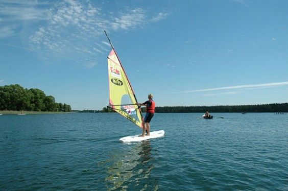
1. Try windsurfing in Cape Cod
Cape Cod is the quintessential New England seaside, with lighthouses, rocky shoreline, and plenty of madras plaid and docksiders. It’s also one of Boston’s most accessible getaways. Cool down in the Atlantic and make braving the crowds worth it by trying out a new water sport, whether it’s wind surfing or stand-up paddle boarding. Hitting the beach just got a whole lot more fun (and active!).
Cost: $35-$90 to rent a windsurfer, $75 for a lesson, and $25-$50 to rent a paddleboard
Activity Level: Easy/Moderate
Distance from your city: 1 hour 25 minutes
Directions: Take 1-93 S to exit 4 on the left to merge onto MA-24. Take exit 14A to merge onto 1-495 S toward Cape Cod. Looking for rentals? Head to 350 Quaker Rd. in North Falmouth.
This rugged bike trail network just opened in 2012, and it’s already a sweet spot for mountain bikers. Single-track terrain means you’re in for a technical ride, but volunteers keep this spot well-maintained with boardwalks and trail blazes. Strap a mountain bike to the car, test out those brakes, and get ready for a day of steep and exciting adventure on two wheels.
Cost: Free!
Activity Level: Strenuous
Distance from your city: 2 hours 20 minutes
Directions: Take I-90 W to exit 26 towards Greenfield Center/North Adams. At the traffic circle, take the 3rd exit onto MA-2 W/Mohawk Trail. Take a slight right and reach the basecamp for the trails at 200 Warfield Rd.
3. Score big views hiking Franconia Ridge, New Hampshire
The New Hampshire Section of the Appalachian Trial is known to be one of the most challenging, and this nine-mile quad-burner is no exception. But once you get above tree line and onto the ridge, you’ll know why this traverse is one of the most popular in the White Mountains. You’ll get breathtaking views for over two miles of above-tree-line trekking, and summit both Mount Lafayette and Mount Lincoln in about six hours. Make sure you’re well prepared and check the weather ahead of time— getting caught on exposed terrain like this during bad weather is no joke.
Cost: Free!
Activity Level: Strenuous
Distance from your city: 2 hours 20 minutes
Directions: Travel north on I-93 for about two hours. Take exit 34B toward Cannon Mountain Tramway/Old Man Historic Site. Merge onto I-93 S and take the exit towards Lafayette Place, where you’ll find the trailhead.
CHICAGO, IL
4. Swim and hike at the Indiana Dunes
There are 15 miles of beach at this park, so if you’re bold enough to dip into Lake Michigan (the fifth-largest lake in the world can be a tad chilly), this is the place to do it. Polar bear plunges not your thing? Hike on a series of trails that take you through wetlands, onto the dunes, or up Mount Baldy, put in your boat and fish, or wander and look out for herons, loons, eagles, sandpipers, and cranes.
Cost: $6 per car
Activity Level: Easy
Distance from your city: 1 hour
Directions: Take I-90 E from Chicago. Take exit 21 to merge on 1-94 E. Take exit 26B to merge onto IN-49 N toward Indiana Dunes. Continue onto N 25 E. At the traffic circle, take the 1st exit onto N 25 E/N State Rd 49. Continue onto Co Rd 100 E and follow signs for the National Lakeshore.
5. Run or bike at Waterfall Glen Forest Preserve
This rolling property boasts the combination of an 8-foot-wide limestone-paved bike path and a series of tougher, unmarked forest trails snaking around the main loop. Run or bike the nine-mile course past woods, lakes, meadows, and marsh, or get adventurous exploring the miles of hikes Waterfall Glen has to offer. It’s the perfect place to escape the city streets for some exercise — and you’re likely to discover a new route or vista every time you return.
Cost: Free!
Activity Level: Moderate
Distance from your city: 30 minutes
Directions: Hop on I-290 W out of Chicago. Take the exit onto I-90 E/I-94 E towards Indiana. Take exit 53 to merge onto I-55 S towards St Louis. Take exit 273A and turn left onto Northgate Rd. The parking area is on your right.
6. Hike the American Discovery Trail
The American Discovery Trail is the only coast-to-coast recreation trail in the U.S., spanning over 6,800 miles and 15 states. Begun in 1989, the trail runs from Delaware to California. Founders wanted the path to showcase true Americana by connecting historic trails, parks, and landmarks. The completion of the trail is still underway, and the Illinois portion just recently opened. Start in Park Forest to catch the eastern end of the trail on the Old Plank Road Trail, a paved rail trail perfect for biking or strolling. Then head west for as long as you want — heck, why not go to California?!
Cost: Free!
Activity Level: Easy
Distance from your city: 40 minutes
Directions: From I-94 E take a slight right onto I-57 S. At exit 340A, merge onto U.S. 30 E into Park Forest. Turn right onto Western Ave to reach Beacon Hill Park. The trail entrance is at the northern end of the park.
Washington, D.C.
7. Run with wild horses at Assateague Island National Seashore
Assateague Island on the Maryland-Virginia border is a beautiful place to explore: It’s got white sand beaches, coastal marshes, four miles of boardwalk bike path, and campsites by the ocean. But the coolest thing of all? Wild horses! The horses on Assateague Island are feral, meaning they’re descendants of once-domesticated horses that now live in the wild — they literally run free on both the Maryland and Virginia sides of the island. Talk about a cool wildlife experience! Just make sure to remember that these are wild animals, so they can be dangerous if you get too close. Feeding or petting the horses isn’t allowed, so enjoy their beauty from afar!
Cost: $15 per car
Activity Level: Easy
Distance from your city: About 3 hours
Directions: Take U.S. 50 E toward Ocean City. Once you reach Ocean City, take exit on the right for MD-611/Stephen Decatur Hwy. Assateague’s north entrance is at the end of Route 611, eight miles south of Ocean City, MD.
8. Cruise with the windows down on Skyline Drive
While we wouldn’t normally recommend driving in a car to get your active nature fix (or as an environmentally-friendly form of travel), this stunning route is an exception. Skyline Drive runs along the ridge of the Shenandoah range for 105 miles, with 75 scenic overlooks from Shenandoah National Park. Roll down the windows, put on your favorite summer playlist, and enter the park at the northernmost point in Front Royal, VA to enjoy up to six hours of uninterrupted cruising through the mountains. Sick of the car? Put it in park and try out your climbing skills on one of several steep rock scrambles or hike a portion of the Appalachian trail — most trailheads start right off the road and will indicate whether they lead to the AT.
Cost: $15 per car
Activity Level: Easy (but if you decide to tie on those hiking boots, things get tougher)
Distance from your city: 1 hour and 20 minutes
Directions: From D.C., take I-66 W through Virginia. Take exit 13 towards Front Royal and follow signs for Shenandoah National Park
9. Boulder and rock climb at Catocin Mountain Park
Though Wolf Rock (1.5 miles from the visitor center at Catocin Mountain Park) seems fairly small, it’s a haven for fans of bouldering. You’ll need a permit to scale this challenging little rock, so call the Visitors Center five days in advance of your trip. Combine this climb with a quick hike up to Chimney Rock by continuing down the trail. Get ready for some nooks, crannies, and crevices that will challenge even the most experienced climbers.
Cost: Free!
Activity Level: Moderate/Strenuous
Distance from your city: 1 hour and 20 minutes
Directions: Take the George Washington Memorial Parkway north to I495 beltway to I270 north 27 miles to Frederick, MD. Take Route 15 17 miles north to Thurmont, MD. Take Route 77 West, the exit sign is marked Catoctin Mountain Park. Travel approximately 3 miles west on 77 and turn right onto Park Central Road. The Visitor Center is on the right.
LOS ANGELES, CA
10. Rappel down waterfalls in the San Gabriel Mountains
In California, the San Gabriel Mountains are THE place for canyoneering thanks to a large number of canyons (series of waterfalls) and their variety of technical difficulty. If you’re an experienced canyoneerer, you can explore on your own, but if not, you can learn! Sign up for an introductory canyoneering course to learn all the basics while making your way down beautiful waterfalls in California’s San Gabriel Mountains. You’ll take a short hike to a “drop point” and learn how to get yourself safely through that spray down the canyon.
Cost: $165 for a day-long lesson
Activity Level: Strenuous
Distance from your city: 50 minutes
Directions: Meeting places vary for each expedition, but expect that all of them will be within the San Gabriel Mountain range.
11. Hike to a grotto at Circle X Ranch
This state park in Malibu is far enough away from the city to escape the sprawl, but close enough to head out for the quick three-mile hike on the Grotto Trail. The highlight? Scramble up some rocks near the end of the trail to reach a natural grotto that fills up during the rainy season. Get there early to avoid the crowds and beat the heat. If you’re looking for a bigger hike, Circle X Ranch offers one other trail, the Canyon View Trail, which connects to the Backbone Trail. This is one of the more challenging hikes in the L.A. area, taking you up 3,000 feet for spectacular views from Inspiration Point.
Cost: Free!
Activity Level: Easy/Moderate
Distance from your city: 1 hour
Directions: Take Pacific Coast Highway to Yerba Buena Road. Turn inland; go 5.4 miles to Circle X Ranch contact station.
12. Enjoy the seaside at Point Mugu State Park
Hiking in the California heat can leave you pretty sweaty —but it’s not so bad if you can jump into the Pacific Ocean afterwards! Check out 70 miles of hiking trails accessible from this beach (all with ocean vistas), and then hit the waves on the five-mile beach to cool off. Ever wanted to camp right on the beach? Turn your day trip into an overnight and pitch a tent in the sand just 40 feet away from the crashing waves of the Pacific. There’s nothing like falling asleep to the sound of the ocean after a day well spent. Just be sure to make a reservation — this place is popular for a reason.
Cost: Free unless you’re camping — price varies depending on site
Activity Level: Easy
Distance from your city: 45 minutes
Directions: Take US-101 N toward I-110 N and take the I-110 S/Harbor Fwy exit to mergo onto CA-110 S. Take the 1-10 W exit, then continue onto CA-1 N. Arrive at 9000 W. Pacific Coast Highway, Malibu CA.
MINNEAPOLIS/SAINT PAUL, MN
13. Hike the trails or rent a kayak at Interstate State Park
Natural basalt gorges formed by flowing lava set this park apart from all the great outdoor spaces in the Twin Cities. Thanks to 300 acres and five miles of trails, you can wander along the bluffs and view the gorges from above, or paddle below on a canoe or kayak. The trails include many man-made stairways, so you can definitely get those quads burning (stair repeats, anyone?). And there’s no shortage of interesting natural features to keep you occupied — check out rock formations like Devil’s Parlor and Bake Oven Pothole, or read about the geology of the park courtesy of the park service’s educational materials.
Cost: Free!
Activity Level: Moderate
Distance from your city: 1 hour
Directions: Take I-35 N to exit 132 towards Taylors Falls. Continue onto Lake Blvd, and then onto St Croix Trail. Turn right onto Milltown Rd. and arrive at the park.
14. Hit the bike path in Menomonie
Looking for some beautiful scenery during a long bike ride? This 14.5 mile trail in Menomonie, Wisconsin follows the Red River Valley via a tough but well-groomed limestone path. You’ll pass by prairies, marshland, forests, farmland, and sandstone bluffs. This trail is good for running as well.
Cost: Free!
Activity Level: Moderate
Distance from your city: 1 hour 20 minutes
Directions: Take I-94 E/US-10 E to exit 32 for County Rd Q toward Knapp. Turn right onto County Rd Q S. Turn left onto WI-29 E/WI-29 Trunk E, and then take another left onto Brick Yard Rd. after 8 miles.
15. Canoe the wetlands at Crew Meadows Wildlife Area
Osprey, otters, cranes, swans, and migrating birds — they’re all there to see in this 30,000-acre wildlife preserve. The best way to explore? Rent a canoe and paddle peacefully down the St. Croix river and into the quietest parts of the wetlands. When you’re ready for some land beneath your feet, head five miles down the road and hike the Sandrock Cliffs Trail to see what you just traversed from above.
Cost: $45-65 per day
Activity Level: Easy/Moderate
Distance from your city: 1 hour and 20 minutes
Directions: Take I-35 North to the Rock Creek/Grantsburg Exit (Highway 70), approximately 34 miles from Forest Lake. Take exit and turn right (EAST) on Highway 70.Follow for 15 miles (into Wisconsin) to the stop lights in Grantsburg.Turn left (NORTH) onto Pine Street.Follow through town to the Visitor Center, which is at the Southwest corner of Crex Meadows.
NASHVILLE, TN

Photo: National Park Service/Marc Muench
16. Road bike on the Natchez Trace Parkway
The Natchez Trace Parkway is 444 miles of roadway spanning from Natchez, Mississippi, to Nashville that’s designated by the National Park Service as a bike route. What does that mean for you? No big trucks, a lower speed limit, no reason to brake (entering traffic uses ramps so you won’t encounter any stoplights), cyclist-friendly rest stops and B&Bs, and numerous trails to get off the road. For cyclists in Nashville, nothing beats this smooth stretch. On top of it, you’ll get great views the whole way with no major commercial developments. Enter at the northern end of the parkway and travel as far south as you’d like!
Cost: Free!
Activity Level: Moderate
Distance from your city: 25 minutes (by car)
Directions: Take I-440 E toward Knoxville. Take exit 1A for US-70S W/West End Ave. Turn right onto TN-1 W/US-70S W and continue onto TN-11 (the Natchez Trace Parkway).
17. Horseback ride at Cedars of Lebanon State Park
This state park has all of the usual offerings: camping, hiking, swimming, and picnicking. But renting a horse for a trail ride will make this daytrip even more worth it (it’s also a darn good workout). Experienced riders can rent their gentle steed and go their own way, while newbies can take a 50-minute guided tour through the park. With the clip-clop of horses hoofs and the Tennessee woods all around you, you’ll forget the Nashville grind in no time.
Cost:$20 per person
Activity Level: Easy
Distance from your city: 45 minutes
Directions: Take I-40 E, following signs for Interstate 40/Knoxville. At exit 232A merge onto State Route 109 S/TN-109 S. Continue onto TN-265 E/Central Pike. Turn right onto TN-10 S/US-231 S, then take the 1st left onto Cedar Forest Rd.
18. Take a hike on the Radnor Lake trails
Radnor Lake State Park has the best range of day hiking trails around, awesome for everything from an easy stroll with your dog on the Otter Creek Road to hiking with real elevation shifts on the South Cove Trail. Head to the park at dawn or dusk to catch the best views of sunlight trickling through the foliage. Radnor Lake State Park does a great job of maintaining their trails, and they never get too crowded.
Cost: Free!
Activity Level: Easy to Strenuous
Distance from your city: 20 minutes
Directions: Take I 65 to Harding Place, Exit 78. Travel west on Harding Place (or Battery Lane) to Granny White Pike. Turn left and travel south to Otter Creek Road and turn left (across from Granny White Market).
New York City, NY
19. Kayak to explore a castle on Pollepel Island
Cold Spring, NY is a town made for nature lovers, and the main attraction is access to the Hudson River. We recommend a kayaking adventure to Pollepel Island, where the remains of an old Scottish millionaire’s castle still stand. The castle is owned by NY State, which means access is limited, but Hudson Valley Outfitters still runs excursions to explore the Bannerman Castle. The whole trip takes five to six hours, including six miles of Hudson kayaking, lunch on the island, and a tour of the castle. This adventure will get you out into the sunshine, cool you off, fill your day, and pack in a little history.
Cost: $130 per person
Activity Level: Moderate
Distance from your city: A little over an hour
Directions: The easiest way is to take Metro North to Cold Spring. If you’re driving, cross the George Washington Bridge on the upper level. Take the Palisades Parkway exit and head north for approximately 35 miles. Go halfway around the circle and cross the Bear Mountain Bridge. Immediately after the bridge, take a left onto 9D. Head north through Garrison to Cold Spring. Take a left at the light onto Main Street. Hudson Valley Outfitters is located near the bottom of the hill on the left.
20. Squeeze through crevices to get to Vanderkeel Falls
When a hike starts with awesome views, you know it’s gonna be good. From the parking lot, take the right fork of the gravel road. In only a half mile you’ll be rewarded with big views of the Shawangunk Ridge and Walkill Valley. That’s just the beginning! On the Ice Caves Loop, the path gets steep and then you’ll have to squeeze through several narrow crevices and climb up wooden ladders before completing the loop. Take Vankeerderkill Falls Trail to enjoy a picnic lunch at the highest waterfall in the area.
Cost: Free!
Activity Level: Strenuous
Distance from your city: 1 hour and 45 minutes
Directions: Take NJ 17 north to the New York Thruway and continue to Exit 16. Proceed west on NY 17 to Exit 119, turn right at the end of the ramp, and continue north on NY 302 for 9.6 miles to Pine Bush, where NY 302 ends. Turn left onto NY 52 and continue for 7.3 miles. Just before the crest of the hill, turn right onto Cragsmoor Road. In 1.3 miles, turn right in front of the Cragsmoor post office, take the next right onto Sam’s Point Road, and follow it to the parking area.
21. Hike part of the Appalachian Trial at Anthony’s Nose
This steep, short hike gets you up above the Hudson river quickly, provides the perfect lunch spot on the sunny rock summit, and follows the AT for the first 20 minutes or so. From the parking area, you’ll have to walk north along the road for a bit. The trailhead is on your right — follow the white blazes of the Appalachian Trail at first (this is the steepest part!) and then turn right onto the Camp Smith Trail (blazes will be blue now). The tough terrain is sure to get your heart rate up, but don’t worry — the whole thing only lasts .6 miles.
Cost: Free!
Activity Level: Strenuous
Distance from your city: 1 hour
Directions: Cross the George Washington Bridge on the upper level. Take the Palisades Parkway exit and head north approximately 35 miles. Go halfway around the circle and cross the Bear Mountain Bridge. Immediately after the bridge, take a left onto 9D. Head north and pass the intersection of 9D and NY-202. The trail head is on your left — you’ll park a few hundred yards before it in a dirt parking lot.
PHILADELPHIA, PA
22. Hike past a waterfall at Bushkill Falls
There are eight waterfalls at this “Niagara of Pennsylvania.” Four trails range in intensity from easy (the green trail) to hard (the red trail) for a choose-your-own-adventure as you make your way up these natural cascades. Though it can get a little touristy, the thundering falls will hold you attention. This is a great place to bring kids or older people due to the options for easier hikes, a picnic area, and a playground. That said, the hundreds of stairs ensure your day hike won’t be too easy.
Cost: $12.50 per person
Activity Level: Easy to Moderate
Distance from your city: 2 hours
Directions: Take I-476 N and get off at the exit for Lehigh Valley. Keep right at the fork, follow signs for US-22 E/I-78 E and merge onto US-22 E. Take the exit onto PA-33 N and get onto the interstate 80 E ramp to Stroudsburg. Take exit 309 and then turn left onto Bushkill Falls Road.
23. Sign up for a ride with the Lancaster Bike Club
Exercise is best with buddies! This massive, open-to-anyone bike club, based out of Lancaster, helps roadies connect with other cyclists with up to 20 rides on the schedule each month. Rides vary every time, with fun events like an “Ice Cream Lover’s ride” that ends with a sweet treat, longer rides for those trying to build endurance, and short jaunts for the newbie. It’s $20 to become a member of the club and start exploring the area outside Philly on your road bike.
Cost: $20
Activity Level: Moderate/Strenuous
Distance from your city: 1 hour and 30 minutes
Directions: Start location varies each ride, but you’ll need to take I-76 W to US-222/Lancaster.
24. Scale the rock wall at High Rocks
High Rocks is a rock formation in Ralph Stover State Park that’s known as a hard climb due to the crumbly shale of the face. Rock climbing options include top roping, a few bolted routes, and lots of fun bouldering. Hike the well-marked trails from the parking lot to discover 17 wall sections with over 60 routes. This is a traditional climbing location that’s best for those with experience — but a challenge is guaranteed.
Cost: Free!
Activity Level: Strenuous
Distance from your city: Just over an hour
Directions: Follow River Road (Route 32) north to Point Pleasant off of I-95 N. Follow River Road and turn left on Cafferty Road. Pass Tohickon Valley Park and Deerwood Campground on the left. Make the next left after Deerwood CG onto Tory Road. Follow Tory Road for 1 mile. The parking area is on your right.
PHOENIX, AZ
25. Cool off at the Prescott Lakes
With temperatures soaring into the hundreds during the Arizona summer, it’s beyond time to go swimming. There are three major lakes in Prescott, and each has its own appeal. A bumpy, bouldery terrain surrounds Watson Lake, supplying plenty of jumping-off points into the water. This is the lake to go water skiing or wakeboarding, since it’s the only one that allows motorboats. If kayaking or canoeing is more your speed, put in at nearby Willow lake, where noisy speedboats are off limits. Goldwater Lake is the most isolated of the three — it’s surrounded by tall pine trees with a hiking trail around the perimeter, and is filled with plenty of rainbow trout waiting to bite.
Cost: Free!
Activity Level: Varies
Distance from your city: 1 hour 45 minutes
Directions: Take I-17 N to the exit for AZ-69. After bearing left onto AZ-69, turn right onto Fain Rd. and continue onto to AZ 89A S. Take exit 317 and follow signs for Watson and Willow Lake Parks. For Goldwater Lake, get of AZ-69 at E Gurley St, turn left onto S Mt Vernon Ave, and continue onto S Senator Hwy, following signs for the park.
26. Pick your own produce at Schnepf Farms
Sometimes urban farming just isn’t enough to get your fresh produce fix. At Schnepf farms, pick your own summer fruits and veggies in the form of organic kale, beets, zucchini, summer squash, carrots, tomatoes, peaches, and plums. This family farm has a long history and they frequently host events, including the annual Peach Festival and Dinner Down the Orchard, a meal prepared with the farm’s produce and served beneath the trees.
Cost: Depends on how much you pick!
Activity Level: Easy
Distance from your city: 1 hour and 30 minutes
Directions: Take the 60 East to Ellsworth. Make a right on Ellsworth Rd. and drive South to Rittenhouse Rd. Make a left at the sign for the farm on the right hand side.
27. Check out petroglyphs from horseback in the Tonto National Forest
Ever wanted to release your inner anthropologist? This unique trail ride takes you through the desert of the Tonto National Forest to a site with ancient petroglyphs from the Hohokam Tribe. Riders are matched with a horse based on riding experience, and guides alter the difficulty of the ride to suit each group’s needs. There are several creek crossings along the way to add a fun challenge to the ride. Reserve a sunset ride for extra-stunning views.
Cost: $45 for 1 hour, $70 for 2 hours
Activity level: Easy
Distance from your city: 50 minutes
Directions: Take AZ-51 N to exit 15B, then merge onto AZ-101 Loop W. Take exit 28 onto N Cave Creek Rd. Turn left onto N Spur Cross Rd, right onto E Grapevine Rd, and then left onto N Spur Cross Rd again. The stables are on the right.
SAN FRANCISCO, CA
28.Hike over the river and through the woods to the beach on the Dipsea Trail
This serene hiking trail offers seven miles of pure Californian beauty. Follow the Redwood Creek from the base of Mt. Tamalpais all the way the Pacific, passing by redwoods, coastal views, shady forest, and down a set of stairs before reaching Stinson beach. The Dipsea Trail makes for a meandering day hike with gorgeous scenery, but also works well for a longer trail run (possibly finishing with a dip in the ocean).
Cost: Free!
Activity Level: Easy/Moderate
Distance from your city: 35 minutes
Directions: The trail starts at Muir Woods National Monument, located 11 miles north of the Golden Gate Bridge. Take Highway 101 to the Highway 1 – Stinson Beach Exit. Follow signs to Muir Woods. The trailhead is in the Muir Woods parking lot.
29. Surf undisturbed at Asilomar State Beach
Anyone can lounge on the beach, but surfing is a great way to get active in the sun (just be sure to wear sunscreen!). Though there’s only about a mile and half of white sand beach at Asilomar State Beach, it’s a lot less crowded than San Francisco’s surrounding beaches, and surfers are welcome. Pack a healthy picnic, bring your own board, and surf’s up!
Cost: Free!
Activity level: Moderate
Distance from your city: Just over 2 hours
Directions: Get on US-101 S toward Interstate 80 E/Oakland. Take the exit toward Monterey and merge onto CA-156 W. Take the CA-68 exit toward Pacific Grove and turn right onto CA-68. Follow signs for Asilomar State Beach and Conference Area.
30. Swim from Alcatraz
This adventure is for serious swimmers only, but if you’re up for the challenge, it’s a once-in-a-lifetime opportunity. Since it’s unsafe to swim from Alcatraz island on your own, SwimArt (an organization that offers swimming programs around San Francisco) will provide transportation and follow along with a support boat. Distance-swimming the 1.3 – 3 miles from Alcatraz to Aquatic Park, Yacht Harbor, or the Golden Gate Bridge is no joke, so SwimArt recommends getting in great shape to prepare. Once you survive this expedition, you’ll always be able to tell your friends about how you escaped from Alcatraz. Pretty cool, huh?
Cost: $130
Activity level: Strenuous
Distance from your city: None
Directions: Groups meets up at Aquatic Park. Take Highway 101 through the Presidio, bear to the right and get on Lambard and then turn left onto Van Ness Avenue. In four blocks turn right onto North Point Stree, and then left onto Polk Street. The park is straight ahead.
SEATTLE, WA
31. Whitewater Raft in Winthrop
Rapids in Winthrop range in level of intensity from class I to class V, so you can literally choose your own adventure depending on your experience, the age of your companions, and everyone’s comfort level. You’ll get views of the lush forest and surrounding mountains the whole time. Looking for something a little more relaxing? Methow Rafting also offers a 1-hour float down the river in an inner tube — the perfect way to beat the heat and zen out.
Cost: Rafting ranges from $55 to $90. Tubing is $25
Activity level: Moderate/Strenuous
Distance from your city: 3 hours
Directions: Take Hwy 530 E to State Route 20 E. Enter Winthrop and take a sharp right onto Radar Rd. Methow River Raft Kayak is on your left.
32. Hike the cascades on the Denny Creek Trail
Keekwulee Falls, just .5 miles up the Denny Creek Trail, is a popular picnic spot, but most hikers stop there. We suggest heading off the beaten path and continuing up the trail to the hidden Snowshoe Falls. Keep going and you’ll reach a wide-open mountain meadow. Since you’ve already made it this far, finish the full 4.5 mile one-way trip to Melakwa lack, where you’ll get panoramic views of the surrounding terrain and a chilly place to dip those tired toes. Just remember to start early so you can squeeze in the whole nine-mile trip before the sun goes down.
Cost: Free!
Activity level: Strenuous
Distance from your city: 1 hour
Directions: From I-90 East take exit 47 (Asael Curtis/Denny Creek). Turn left to continue along the overpass. Turn left onto Denny Creek Road and travel 2.5 miles, turning left just after the Denny Creek Campground. The trailhead is at the road’s end.
33. Take the ferry to hike Moran Island’s highest point
Not only will you get stunning views on the ferry ride over to Moran State Park, but you can also reach the highest point on the San Juan Islands by ascending the 2,409-foot-high Mt. Constitution. A stone observation tower at the top gives you a 360-degree view of the islands, the Cascade mountain range, Northern Washington, and Canada. Since this trip is a little far to do in one day, consider camping overnight on the island and enjoy the feeling of being completely surrounded by nature.
Cost: The ferry costs $50 per vehicle or $12.45 per person
Activity level: Strenuous
Distance from your city: 3 hours
Directions: From I-5 take Hwy 20 exit westbound to Anacortes. Follow signs to San Juan/ Sidney, B.C. ferries. Take ferry to Orcas Island. Turn left after exiting the ferry, and follow signs to Moran State Park (approximately 14 miles from the ferry).
Got some favorite day trips near your city? Share ‘em in the comments below or tweet the author @skoppelkam.